Earth
- Earth is the only planet in our Solar System that has water and air.
- Earth has land masses and water bodies.
- The large land masses on Earth are called continents.
- The large water bodies on Earth are called oceans.
Shape of the Earth
- Ferdinand Magellan Sailed around the world and proved that Earth is round.
- Pictures taken from space have proved that Earth is Like a sphere but is slightly flattened at the top and at the bottom.
What is the globe?
This globe is a simple and accurate model of the Earth which shows the distribution of land and water on the surface of the Earth.
On the globe we can also see the correct shape, size and location of the continents and oceans.
We cannot always use to study the Earth from the Globe for the following reason
- A globe is difficult to carry around.
- A globe is small and all the details of a place cannot be shown on it.
- We cannot make a globe for a part of the Earth.
- Only 1/2 of the Earth can be seen at a time on a globe.
Also Check- Know Your Planet Question Answers
What is a map?
A map is a representation of the Earth surface or a part of it on a flat surface.
Map comes from the Latin word mappo.
Gerardus Mercator A Flemish Macmaker, was the 1st to publish a collection of maps.
The book of maps is called an Atlas.
Features of map
We can draw maps on a flat surface to show continents, countries, cities and even a neighborhood.
We can draw a map of our school and show all the details on it.
Map is better than the globe Especially when we want to represent Small areas. It can be fairly and accurately represented on a map.
Types of map
Physical map
Physical map shows physical features of a place such as mountains plateau’s plains and rivers.
Political maps
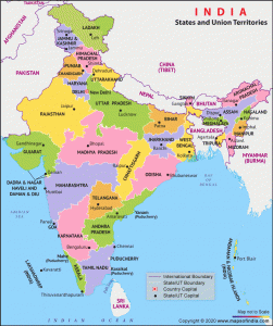
Country States and their capitals are shown on political maps
Climatic maps
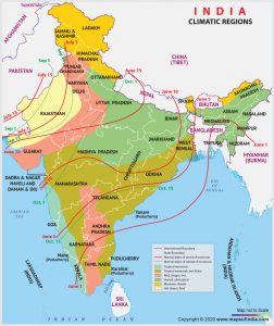
Generally information about climate and rainfall of the region is shown in climatic maps.
Besides these there are maps that tell us about the industries, population,transport ,minerals, crops, soil, natural resources ,forest and wildlife of a region.
How to read maps?
Maps give us lots of information about a country or a place.
Every map has some basic features which helps us to understand the information it provides.
Features of maps are as follows
Directions
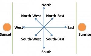
All maps follow a system of directions
The 4 major directions are
North
South
East
And West
The top of the map is North, Bottom is South, East is to the right and West is to the left.
The direction on a map can also be shown by an arrow marked “N”. Which points towards the North direction. Other directions are then easy to find.
We can also mark the 4 intermediate directions on a map.
Northeast- It lies between the North and the East.
Northwest- It lies between the North and the West.
Southeast- It lies between the South and the East.
Southwest- It lies between the South and the West.
Scale
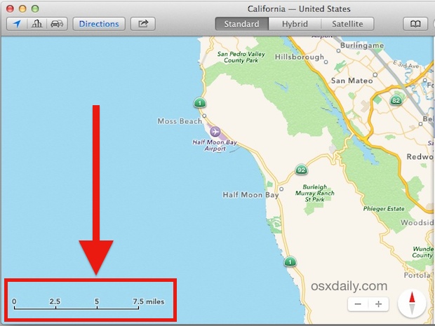
The ratio between the distance on the ground and the distance on the map is known as the scale of the map.
It is not possible to show the actual size of the Earth on a map because it is too large.
For example the distance between Delhi and Mumbai is 1414 kms. It is not possible to show these cities 1414 km from each other on a map. Therefore this distance is represented by a smaller unit on the map.In this case we would write it as 5 cm: 200km.
Maps are always drawn to scale.
Symbols
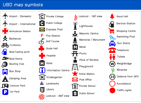
On the map we don’t have enough space to show Mountains rivers, legs, bridges, dam’s ,temples, churches and railway tracks.
To show this information on map symbols are used.
For example, the land boundary of a country is shown by thick dashes and dots in black.
A city is marked by a small circle.
Colors
Different colors are used to show various things on a map.
Maps follow a common color scheme
For example on a physical map
What bodies are shown in the shade of blue.
Light blue is used for shallow waters.
Darker shades of blue are used for deep waters.
Planes or lowlands are shown in shades of green.
Highlights are shown in shades of Brown.
The key is given on a map to Help us understand the color scheme and symbol used.
Actually it’s working very much i am in Techno india group public school on west bengal coochbehar what was your school? please answer me